WIKIMAPA OF CAMPIÑA DEL HENARES
Introduction
The wikimap Resource Countryside Henares is a project of the Vicus Asociación Futura, in collaboration with the Local Action Group of Campiña del Henares, to document all in one set of resources in the region.
* Natural Resources * Cultural Resources * Transport and Communications * Tourist Services * Other Services
This is a free and open service, based on a geographic information system layers, including interactive personal information and points of interest supplied by the connoisseurs of the ground.
As a wiki-type project, the pages are viewed and edited through a standard web browser and using a simple interface. Moreover, the contributions to each input can be collected, refined content with increasing the volume of contributions.
The primary objective of the project is the enhancement of rural assets, encouraging the participation of residents and visitors with respect to knowledge of existing resources in the region.
The Region
La Campiña del Henares Spanish is a region located southeast of the Comunidad de Madrid, bordering the province of Guadalajara, between the river Henares and Tajuña.
This area has great agricultural tradition that has remained to this day, resulting in a landscape dotted with dryland crops, olive groves and vineyards, along with a wide variety of landscapes and vegetation that give this region a key ecological Mediterranean ecosystem where you can enjoy the scenery and natural surroundings of great beauty.
The legacy of the marked features of current features of the Shire, so we still find many traces of various civilizations that have left their mark on this territory.
Municipalities
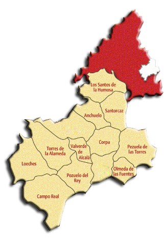
The Campiña del Henares consists of the following municipalities:
- Anchuelo
- Campo Real
- Corpa
- Loeches
- Los Santos de la Humosa
- Olmeda de las Fuentes
- Pezuela de las Torres
- Pozuelo del Rey
- Santorcaz
- Torres de la Alameda
- Valverde de Alcalá
The Routes
County roads are proposed to invite you to know and enjoy thepatrimony cultural, artistic, historical, architectural and natural of the Campiña del Henares, although there are many more routes and opportunities to discover.
ROUTE 1
The first proposed route runs through the municipalities of Campo Real, Pozuelo del Rey, Loeches, Torres de la Alameda and Valverde de Alcala.
The route that arises is divided into 5 sections that begin and end in the municipalities mentioned above.
Special care is recommended in the sections where we should go on the road, although the dirt roads also need to pay attention and that they circulate vehicles.
This route has steep slopes and present a good state roads to be traveled.
| ROUTE PROFILE | |||||||||
|---|---|---|---|---|---|---|---|---|---|
| Total distance: 28 km | |||||||||
| Difficulty: Medium-Low | Municipalities | ||||||||
| Sections | A | Campo Real – Pozuelo del Rey | |||||||
| B | Pozuelo del Rey – Loeches | ||||||||
| C | Loeches – Torres de la Alameda | ||||||||
| D | Torres de la Alameda – Valverde de Alcalá | ||||||||
| E | Valverde de Alcalá – Pozuelo del Rey | ||||||||
| Sections | A | B | C | D | E | ||||
| Distances | 6 Km | 7,5 Km | 3,5 Km | 5 Km | 6 Km | ||||
| At Horse | Times | 0,5 h | 1,5 h | 0,4 h | 0,5 h | 1,2 h | |||
| Difficulty | Low | Medium | Low | Low | Medium | ||||
| By Bicycle | Times | 0,3 h | 0,45 h | 0,2 h | 0,3 h | 0,3 h | |||
| Difficulty | Low | Medium | Low | Low | Low | ||||
| On Foot | Times | 1,15 h | 1,4 h | 0,45 h | 1,05 h | 1,30 h | |||
| Difficulty | Low | Medium | Low | Low | Low | ||||
ROUTE 2
The second route includes the municipalities of Pozuelo del Rey, Nuevo Baztán, Pezuela de las Torres and Olmeda de las Fuentes.
The route that arises is divided into 4 sections that begin and end in the municipalities mentioned above.
The sections that are proposed are made mostly of dirt roads, although a small section that has to be done by road, so special care should be paid.
The most notable section of this route is known as the Tranche B Path Valmores, which begins and ends in New Baztán.
| ROUTE PROFILE | ||||||||
|---|---|---|---|---|---|---|---|---|
| Total distance: 23 km | ||||||||
| Difficulty: Medium-High | Municipalities | |||||||
| Sections | A | Pozuelo del Rey - Nuevo Baztán | ||||||
| B | Nuevo Baztán - Nuevo Baztán | |||||||
| C | Pezuela de las Torres – Nuevo Baztán | |||||||
| D | Olmeda de las Fuentes – Nuevo Baztán | |||||||
| Sections | A | B | C | D | ||||
| Distances | 6,5 Km | 6,5 Km | 7 Km | 7 Km | ||||
| At Horse | Times | 0,5 h | 1,3 h | 1,3 h | 0,45 h | |||
| Difficulty | Low | High | Medium-High | High | ||||
| By Bicycle | Times | 0,4 h | 1 h | 1 h | 0,25 h | |||
| Difficulty | Low | High | Medium-High | High | ||||
| On Foot | Times | 1,15 h | 1,4 h | 1,3 h | 0,35 h | |||
| Difficulty | Low | Medium-High | Medium-High | Medium-High | ||||
ROUTE 3
The third route runs through the following municipalities: Los Santos de La Humosa, Anchuelo, Santorcaz, Corpa, Villalbilla and Pezuela de Las Torres.
The route that arises is divided into 7 sections that begin and end in the municipalities mentioned above.
The sections that are proposed are carried out on dirt roads except for a small section that is carried by road, should take special caution in that section paved.
| ROUTE PROFILE | |||||||||||||
|---|---|---|---|---|---|---|---|---|---|---|---|---|---|
| Total distance: 31,5 km | |||||||||||||
| Difficulty: Medium-High | Municipios | ||||||||||||
| Sections | A | Los Santos de la Humosa - Anchuelo | |||||||||||
| B | Los Santos de la Humosa - Santorcaz | ||||||||||||
| C | Anchuelo – Santorcaz | ||||||||||||
| D | Anchuelo – Corpa | ||||||||||||
| E | Santorcaz – Corpa | ||||||||||||
| F | Pezuela de las Torres – Corpa | ||||||||||||
| G | Villalbilla – Anchuelo | ||||||||||||
| Sections | A | B | C | D | E | F | G | ||||||
| Distances | 4 Km | 3 Km | 2,5 Km | 5 Km | 5 Km | 8 Km | 4 Km | ||||||
| At Horse | Times | 0,55 h | 0,45 h | 0,30 h | 1,10 h | 1,10 h | 1,55 h | 0,55 h | |||||
| Difficulty | Low | High | Medium | Low | Low | Low | Medium | ||||||
| By Bicycle | Times | 0,20 h | 0,25 h | 0,25 h | 0,4 h | 0,4 h | 0,45 h | 0,25 h | |||||
| Difficulty | Low | Medium-High | Low | Low | Low | Low | Low | ||||||
| On Foot | Times | 0,55 h | 0,45 h | 0,35 h | 1 h | 1 h | 1,5 h | 0,55 h | |||||
| Difficulty | Low | Medium-High | Medium | Low | Low | Low | Medium | ||||||
Other Routes